S Hempstead's Livability
-
D+
Affordability -
A+
Housing -
B
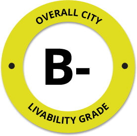
Job Market -
B-
Diversity -
B+
Crime -
C
Commute -
B
Education -
B
Weather -
A+
Amenities
About S Hempstead, NY
S Hempstead, NY is located in Nassau County in the state of New York.
The total City Population for S Hempstead is about 56,435 with about 13,251 people per square mile.
The Average Home Value is $320,000, which is roughly 7% higher than the Average Home Value of $296,520 for the state of New York, and roughly 32% higher than the National Average of $217,072.
The Median Income Per Household is about $64,097, which is roughly 18% lower than the Average Median Income Per Household of $77,890 for the state of New York, and roughly 1% lower higher than the National Average of $65,026.


Quick Stats
Demographic Details
Average # of People Per Household: 3.44Male Population Estimate: 49.2%
Female Population Estimate: 50.8%
Median Age: 32.7
Male Median Age: 31.1
Female Median Age: 34.7
Racial Demographic Estimates
Hispanic:43.2%
White:27.23%
Other:25.29%
Asian:1.92%
Indian:1.8%
Hawaiian:0.22%
Voting


Voting Results by Party
Republican: 44.25%
Other: 1.3%
Libertarian: 0.49%
Green: 0.26%
Crime Details
NOTE: Crime is available at the County level so this doesn't necessarily represent the city of S Hempstead specifically.
Average # of Homicides for Nassau County: About 1.63893 per 100,000 People
(last recorded in 2021)
Average # of Violent Crimes for Nassau County: About 143.663 per 100,000 People
(last recorded in 2021)
Nassau County is about 59% lower than the national average of about 4 homicides per 100,000 people, and about 50% lower than the national average of about 288 violent crimes per 100,000 people.
Employment
The Unemployment Rate for S Hempstead is about 4.9%.
New York is ranked #2 out of 52 for Best and Worst States to Work in America, with an overall score of 85.46 out of 100.

Wage Policies
Overall Wage Policy Score: 69.89The average living wage for the state of New York is $35.98/hr, while the states minimum wage is $12.50/hr, which can be set above the state standard, and is extended to farm workers. This gives New York a minimum wage score of 66.97 compared to all other states.
The minimum wage for tipped employees is $8.35/hr, which gives New York a minimum wage for tipped employees score of 57.2 compared to all other states.
The weekly unemployment (UI) benefit for New York is $250.00, resulting in a UI benefit score of 50.49 compared to all other states.
Worker Protection Policies
Overall Worker Protection Score: 71.43✓ New York does offer protections for workplace breastfeeding.
✓ New York does mandate equal pay across gender and race.
✓ New York does prohibit pay secrecy practices in the workplace.
✓ New York does restrict access to salary history to reduce gender and racial bias.
✓ New York does provide some form of paid family leave.
✓ New York does provide some form of paid sick leave.
X New York does not provide flexible scheduling of worker shifts.
✓ New York does not mandate pay reporting or "call-in" pay by employers.
✓ New York does not provide split shift pay regulation.
X New York does not provide workers advanced notice of shift scheduling.
✓ New York does provide some form of sexual harassment protection in state law.
✓ New York does extend workers compensation mandates to farmworkers.
✓ New York does not extend worker protections to domestic workers.
Right To Organize Policies
Overall Right To Organize Score: 70✓ New York does legalize project labor agreements to ensure a fair wage to workers on contract.
✓ New York does not protect workers against wage theft retaliation.
✓ New York does partially require collective bargaining for public workers.
✓ New York does provide collective bargaining for teachers.
✓ New York does provide wage negotiations for teachers.
A global organization that fights inequality to end poverty and injustice.
Nearby Location
- South Hempstead, NY ( 1.34 mi. )
- Citibank, NY ( 1.44 mi. )
- West Hempstead, NY ( 1.59 mi. )
- W Hempstead, NY ( 1.60 mi. )
- Hofstra Univ, NY ( 1.64 mi. )
- Uniondale, NY ( 1.80 mi. )
- Garden City S, NY ( 1.97 mi. )
- Mitchell Field, NY ( 1.97 mi. )
- Roosevelt Field, NY ( 1.97 mi. )
- Village Of Garden City, NY ( 1.97 mi. )
- Vlg Gdn City, NY ( 1.97 mi. )
- Garden City, NY ( 2.18 mi. )
- Lakeview, NY ( 2.19 mi. )
- Garden City South, NY ( 2.22 mi. )
- Rockville Center, NY ( 2.42 mi. )
- Rockville Ctr, NY ( 2.42 mi. )
- RVC, NY ( 2.42 mi. )
- Roosevelt, NY ( 2.43 mi. )
- Rockville Centre, NY ( 2.67 mi. )
- Hempstead, NY ( 2.68 mi. )
- Franklin Sq, NY ( 2.78 mi. )
- Franklin Square, NY ( 2.96 mi. )
- Malverne, NY ( 3.23 mi. )
- North Merrick, NY ( 3.25 mi. )
- N Baldwin, NY ( 3.30 mi. )
- North Baldwin, NY ( 3.30 mi. )
- Mineola, NY ( 3.34 mi. )
- Carle Place, NY ( 3.43 mi. )
- East Meadow, NY ( 3.43 mi. )
- Baldwin, NY ( 3.50 mi. )
- E Meadow, NY ( 3.62 mi. )
- Stewart Manor, NY ( 3.63 mi. )
- Garden City Park, NY ( 3.71 mi. )
- Freeport, NY ( 3.88 mi. )
- New Hyde Park, NY ( 4.04 mi. )
- Lynbrook, NY ( 4.06 mi. )
- East Williston, NY ( 4.20 mi. )
- E Williston, NY ( 4.21 mi. )
- Williston Pk, NY ( 4.21 mi. )
- Williston Park, NY ( 4.22 mi. )
- South Floral Park, NY ( 4.25 mi. )
- N Merrick, NY ( 4.35 mi. )
- North Bellmore, NY ( 4.35 mi. )
- Hillside Manor, NY ( 4.38 mi. )
- Garden Cty Pk, NY ( 4.40 mi. )
- Gdn City Park, NY ( 4.40 mi. )
- Hillside Mnr, NY ( 4.40 mi. )
- Lakeville Estates, NY ( 4.40 mi. )
- Manhasset Hl, NY ( 4.40 mi. )
Additional Location Details
Zip Code(s): 11550Latitude: 40.700705
Longitude: -73.620907
TimeZone: Eastern (GMT -05:00)
Daylight Saving: Yes
Region: Northeast
Average Elevation: 58.0 ft.
Area Code(s): 516