Mamaroneck's Livability
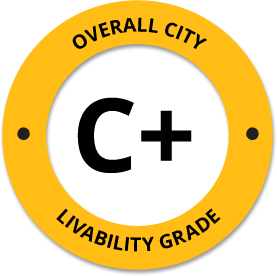
-
F
Affordability -
B-
Housing -
C+
Job Market -
C+
Diversity -
B
Crime -
C+
Commute -
A-
Education -
B-
Weather -
A+
Amenities
About Mamaroneck, NY
Mamaroneck, NY is located in Westchester County in the state of New York.
The total City Population for Mamaroneck is about 31,381 with about 1,707 people per square mile.
The Average Home Value is $900,767, which is roughly 67% higher than the Average Home Value of $296,520 for the state of New York, and roughly 76% higher than the National Average of $217,072.
The Median Income Per Household is about $156,782, which is roughly 50% higher than the Average Median Income Per Household of $77,890 for the state of New York, and roughly 59% higher higher than the National Average of $65,026.


Quick Stats
Demographic Details
Average # of People Per Household: 2.65Male Population Estimate: 52.1%
Female Population Estimate: 47.9%
Median Age: 38.9
Male Median Age: 37.6
Female Median Age: 41.9
Racial Demographic Estimates
Hispanic:17.4%
Other:8.6%
Asian:4.7%
Black:2.9%
Hawaiian:0.1%
Indian:0.1%
Voting


Voting Results by Party
Republican: 31.31%
Libertarian: 0.56%
Other: 0.29%
Green: 0.28%
Crime Details
NOTE: Crime is available at the County level so this doesn't necessarily represent the city of Mamaroneck specifically.
Average # of Homicides for Westchester County: About 1.99773 per 100,000 People
(last recorded in 2021)
Average # of Violent Crimes for Westchester County: About 220.606 per 100,000 People
(last recorded in 2021)
Westchester County is about 49% lower than the national average of about 4 homicides per 100,000 people, and about 23% lower than the national average of about 288 violent crimes per 100,000 people.
Employment
The Unemployment Rate for Mamaroneck is about 5.3%.
New York is ranked #2 out of 52 for Best and Worst States to Work in America, with an overall score of 85.46 out of 100.

Wage Policies
Overall Wage Policy Score: 69.89The average living wage for the state of New York is $35.98/hr, while the states minimum wage is $12.50/hr, which can be set above the state standard, and is extended to farm workers. This gives New York a minimum wage score of 66.97 compared to all other states.
The minimum wage for tipped employees is $8.35/hr, which gives New York a minimum wage for tipped employees score of 57.2 compared to all other states.
The weekly unemployment (UI) benefit for New York is $250.00, resulting in a UI benefit score of 50.49 compared to all other states.
Worker Protection Policies
Overall Worker Protection Score: 71.43✓ New York does offer protections for workplace breastfeeding.
✓ New York does mandate equal pay across gender and race.
✓ New York does prohibit pay secrecy practices in the workplace.
✓ New York does restrict access to salary history to reduce gender and racial bias.
✓ New York does provide some form of paid family leave.
✓ New York does provide some form of paid sick leave.
X New York does not provide flexible scheduling of worker shifts.
✓ New York does not mandate pay reporting or "call-in" pay by employers.
✓ New York does not provide split shift pay regulation.
X New York does not provide workers advanced notice of shift scheduling.
✓ New York does provide some form of sexual harassment protection in state law.
✓ New York does extend workers compensation mandates to farmworkers.
✓ New York does not extend worker protections to domestic workers.
Right To Organize Policies
Overall Right To Organize Score: 70✓ New York does legalize project labor agreements to ensure a fair wage to workers on contract.
✓ New York does not protect workers against wage theft retaliation.
✓ New York does partially require collective bargaining for public workers.
✓ New York does provide collective bargaining for teachers.
✓ New York does provide wage negotiations for teachers.
A global organization that fights inequality to end poverty and injustice.
Nearby Location
- Larchmont, NY ( 1.30 mi. )
- New Rochelle, NY ( 2.05 mi. )
- Wykagyl, NY ( 2.07 mi. )
- Rosedale, NY ( 3.40 mi. )
- Eastchester, NY ( 3.42 mi. )
- Scarsdale, NY ( 3.50 mi. )
- Tuckahoe, NY ( 3.92 mi. )
- Edgemont, NY ( 3.93 mi. )
- Heathcote, NY ( 3.93 mi. )
- Scarsdale Park, NY ( 3.93 mi. )
- Bronxville, NY ( 4.07 mi. )
- Fleetwood, NY ( 4.23 mi. )
- Pelham, NY ( 4.28 mi. )
- Gedney, NY ( 4.38 mi. )
- Pelham Manor, NY ( 4.63 mi. )
- Mount Vernon, NY ( 4.69 mi. )
- Mt Vernon, NY ( 5.19 mi. )
- Greenville, NY ( 5.24 mi. )
- Centuck, NY ( 5.34 mi. )
- White Plains, NY ( 5.37 mi. )
- Rye, NY ( 5.42 mi. )
- Hartsdale, NY ( 5.68 mi. )
- Harrison, NY ( 5.69 mi. )
- Port Chester, NY ( 5.95 mi. )
- Yonkers, NY ( 6.18 mi. )
- Wakefield, NY ( 6.18 mi. )
- Portchester, NY ( 6.58 mi. )
- Purchase, NY ( 6.64 mi. )
- Ardsley, NY ( 6.71 mi. )
- Sands Point, NY ( 6.73 mi. )
- Rye Brook, NY ( 6.76 mi. )
- Hastings On Hudson, NY ( 7.05 mi. )
- Hastings Hdsn, NY ( 7.05 mi. )
- Hastings Hudson, NY ( 7.05 mi. )
- Baychester, NY ( 7.15 mi. )
- Esplanade, NY ( 7.15 mi. )
- Manorhaven, NY ( 7.45 mi. )
- West Harrison, NY ( 7.48 mi. )
- East White Plains, NY ( 7.48 mi. )
- W Harrison, NY ( 7.48 mi. )
- Westchester County Airport, NY ( 7.48 mi. )
- Belle Haven, CT ( 7.57 mi. )
- Glenville, CT ( 7.62 mi. )
- North White Plains, NY ( 7.71 mi. )
- Greenburgh, NY ( 7.79 mi. )
- Dobbs Ferry, NY ( 7.88 mi. )
- Allerton, NY ( 7.93 mi. )
- Mosholu, NY ( 7.93 mi. )
- Van Cott, NY ( 7.93 mi. )
Additional Location Details
Zip Code(s): 10538, 10543 (2 Total Zip Codes)Latitude: 40.944300
Longitude: -73.748800
TimeZone: Eastern (GMT -05:00)
Daylight Saving: Yes
Region: Northeast
Average Elevation: 28.0 ft.
Area Code(s): 914