Albany's Livability
-
C
Affordability -
A+
Housing -
B
Job Market -
C-
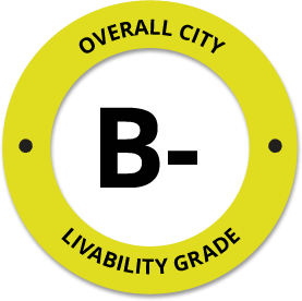
Diversity -
B-
Crime -
A-
Commute -
D+
Education -
C+
Weather -
A+
Amenities
About Albany, NY
Albany, NY is located in Albany County in the state of New York.
The total City Population for Albany is about 99,402 with about 1,747 people per square mile.
The Average Home Value is $186,829, which is roughly 37% lower than the Average Home Value of $296,520 for the state of New York, and roughly 14% lower than the National Average of $217,072.
The Median Income Per Household is about $52,583, which is roughly 32% lower than the Average Median Income Per Household of $77,890 for the state of New York, and roughly 19% lower higher than the National Average of $65,026.


Quick Stats
Demographic Details
Average # of People Per Household: 0.48Male Population Estimate: 46.9%
Female Population Estimate: 53.1%
Median Age: 31.6
Male Median Age: 8.5
Female Median Age: 9.1
Racial Demographic Estimates
Black:27.7%
Hispanic:9.9%
Asian:7.5%
Other:3.1%
Hawaiian:0.2%
Indian:0.1%
Voting


Voting Results by Party
Republican: 33.01%
Other: 1.21%
Libertarian: 0.98%
Green: 0.5%
Crime Details
NOTE: Crime is available at the County level so this doesn't necessarily represent the city of Albany specifically.
Average # of Homicides for Albany County: About 2.82987 per 100,000 People
(last recorded in 2021)
Average # of Violent Crimes for Albany County: About 348.218 per 100,000 People
(last recorded in 2021)
Albany County is about 28% lower than the national average of about 4 homicides per 100,000 people, and about 17% higher than the national average of about 288 violent crimes per 100,000 people.
Employment
The Unemployment Rate for Albany is about 7.4%.
New York is ranked #2 out of 52 for Best and Worst States to Work in America, with an overall score of 85.46 out of 100.

Wage Policies
Overall Wage Policy Score: 69.89The average living wage for the state of New York is $35.98/hr, while the states minimum wage is $12.50/hr, which can be set above the state standard, and is extended to farm workers. This gives New York a minimum wage score of 66.97 compared to all other states.
The minimum wage for tipped employees is $8.35/hr, which gives New York a minimum wage for tipped employees score of 57.2 compared to all other states.
The weekly unemployment (UI) benefit for New York is $250.00, resulting in a UI benefit score of 50.49 compared to all other states.
Worker Protection Policies
Overall Worker Protection Score: 71.43✓ New York does offer protections for workplace breastfeeding.
✓ New York does mandate equal pay across gender and race.
✓ New York does prohibit pay secrecy practices in the workplace.
✓ New York does restrict access to salary history to reduce gender and racial bias.
✓ New York does provide some form of paid family leave.
✓ New York does provide some form of paid sick leave.
X New York does not provide flexible scheduling of worker shifts.
✓ New York does not mandate pay reporting or "call-in" pay by employers.
✓ New York does not provide split shift pay regulation.
X New York does not provide workers advanced notice of shift scheduling.
✓ New York does provide some form of sexual harassment protection in state law.
✓ New York does extend workers compensation mandates to farmworkers.
✓ New York does not extend worker protections to domestic workers.
Right To Organize Policies
Overall Right To Organize Score: 70✓ New York does legalize project labor agreements to ensure a fair wage to workers on contract.
✓ New York does not protect workers against wage theft retaliation.
✓ New York does partially require collective bargaining for public workers.
✓ New York does provide collective bargaining for teachers.
✓ New York does provide wage negotiations for teachers.
A global organization that fights inequality to end poverty and injustice.
Nearby Location
- Stuyvesant Plaza, NY ( 2.10 mi. )
- Stuyvsnt Plz, NY ( 2.10 mi. )
- Roessleville, NY ( 2.11 mi. )
- Albany Brm, NY ( 2.34 mi. )
- Audit And Control Dept, NY ( 2.34 mi. )
- Empire State Plaza, NY ( 2.34 mi. )
- Mental Hygiene Dept, NY ( 2.34 mi. )
- Ny Agr And Mkts, NY ( 2.34 mi. )
- Ny Assembly, NY ( 2.34 mi. )
- Ny Civil Serv Dept, NY ( 2.34 mi. )
- Ny Conservation Dept, NY ( 2.34 mi. )
- Ny Dept Commerce, NY ( 2.34 mi. )
- Ny Dept Of Motor Vehicles, NY ( 2.34 mi. )
- Ny Dept Trans, NY ( 2.34 mi. )
- Ny Educ Dept, NY ( 2.34 mi. )
- Ny Empl Retirement, NY ( 2.34 mi. )
- Ny Health Dept, NY ( 2.34 mi. )
- Ny Hghr Educ Serv Corp, NY ( 2.34 mi. )
- Ny Labor Div Empl, NY ( 2.34 mi. )
- Ny Labor Unemp Ins, NY ( 2.34 mi. )
- NY Park And Rec Dept, NY ( 2.34 mi. )
- Ny Secretary Of State, NY ( 2.34 mi. )
- Ny Soc Serv Dept, NY ( 2.34 mi. )
- NY Standards And Purc, NY ( 2.34 mi. )
- Ny State Campus, NY ( 2.34 mi. )
- Ny State Dept Financial Svc, NY ( 2.34 mi. )
- Ny Tele Co, NY ( 2.34 mi. )
- Ny Workman Comp, NY ( 2.34 mi. )
- NYS Tax Processing Ctr, NY ( 2.34 mi. )
- S U N Y, NY ( 2.34 mi. )
- S U N Y 99 Wash, NY ( 2.34 mi. )
- State Office Bldg, NY ( 2.34 mi. )
- US Postal Service, NY ( 2.34 mi. )
- New York State Gov, NY ( 2.36 mi. )
- NYS Dept Of Tax & Finance, NY ( 2.36 mi. )
- McKownville, NY ( 2.76 mi. )
- Siena, NY ( 3.03 mi. )
- Kenwood, NY ( 3.22 mi. )
- Loudonville, NY ( 3.23 mi. )
- Elsmere, NY ( 3.24 mi. )
- Delmar, NY ( 3.35 mi. )
- Rensselaer, NY ( 3.62 mi. )
- Menands, NY ( 4.01 mi. )
- Westmere, NY ( 4.13 mi. )
- Slingerlands, NY ( 4.22 mi. )
- Bethlehem Center, NY ( 4.46 mi. )
- Glenmont, NY ( 4.50 mi. )
- Newtonville, NY ( 4.50 mi. )
- Colonie, NY ( 5.09 mi. )
Additional Location Details
Zip Code(s): 12201, 12202, 12203, 12204, 12205, 12206, 12207, 12208, 12209, 12210, 12222, 12223, 12226, 12228, 12229, 12230, 12231, 12232, 12233, 12234, 12235, 12236, 12237, 12238, 12239, 12240, 12241, 12242, 12243, 12244, 12245, 12246, 12248, 12250, 12255, 12257, 12260, 12261 (38 Total Zip Codes)Latitude: 42.666400
Longitude: -73.798700
TimeZone: Eastern (GMT -05:00)
Daylight Saving: Yes
Region: Northeast
Average Elevation: 169.1 ft.
Area Code(s): 518, 838