Westfield's Livability
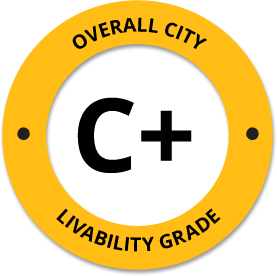
-
A-
Affordability -
D-
Housing -
B
Job Market -
B-
Diversity -
B
Crime -
A-
Commute -
C-
Education -
C
Weather -
D-
Amenities
About Westfield, ME
Westfield, ME is located in Aroostook County in the state of Maine.
The total City Population for Westfield is about 569 with about 7 people per square mile.
The Average Home Value is $81,931, which is roughly 58% lower than the Average Home Value of $196,619 for the state of Maine, and roughly 62% lower than the National Average of $217,072.
The Median Income Per Household is about $35,833, which is roughly 40% lower than the Average Median Income Per Household of $59,885 for the state of Maine, and roughly 45% lower higher than the National Average of $65,026.


Quick Stats
Demographic Details
Average # of People Per Household: 2.42Male Population Estimate: 47.8%
Female Population Estimate: 52.2%
Median Age: 60.2
Male Median Age: 45.9
Female Median Age: 49.1
Racial Demographic Estimates
Indian:4%
Black:0.4%
Hispanic:0%
Asian:0%
Hawaiian:0%
Other:0%
Voting


Voting Results by Party
Democratic: 38.54%
Other: 1.44%
Libertarian: 1.16%
Green: 0.64%
Crime Details
NOTE: Crime is available at the County level so this doesn't necessarily represent the city of Westfield specifically.
Average # of Homicides for Aroostook County: About 2.72019 per 100,000 People
(last recorded in 2021)
Average # of Violent Crimes for Aroostook County: About 120.427 per 100,000 People
(last recorded in 2021)
Aroostook County is about 31% lower than the national average of about 4 homicides per 100,000 people, and about 58% lower than the national average of about 288 violent crimes per 100,000 people.
Employment
The Unemployment Rate for Westfield is about 4.7%.
Maine is ranked #11 out of 52 for Best and Worst States to Work in America, with an overall score of 68.97 out of 100.

Wage Policies
Overall Wage Policy Score: 72.42The average living wage for the state of Maine is $32.41/hr, while the states minimum wage is $12.15/hr, which can be set above the state standard, and is extended to farm workers. This gives Maine a minimum wage score of 81.24 compared to all other states.
The minimum wage for tipped employees is $6.08/hr, which gives Maine a minimum wage for tipped employees score of 35.6 compared to all other states.
The weekly unemployment (UI) benefit for Maine is $307.18, resulting in a UI benefit score of 100 compared to all other states.
Worker Protection Policies
Overall Worker Protection Score: 71.43✓ Maine does offer protections for workplace breastfeeding.
✓ Maine does mandate equal pay across gender and race.
✓ Maine does prohibit pay secrecy practices in the workplace.
✓ Maine does restrict access to salary history to reduce gender and racial bias.
X Maine does provide some form of paid family leave.
✓ Maine does provide some form of paid sick leave.
X Maine does not provide flexible scheduling of worker shifts.
X Maine does not mandate pay reporting or "call-in" pay by employers.
X Maine does not provide split shift pay regulation.
X Maine does not provide workers advanced notice of shift scheduling.
✓ Maine does provide some form of sexual harassment protection in state law.
✓ Maine does extend workers compensation mandates to farmworkers.
X Maine does not extend worker protections to domestic workers.
Right To Organize Policies
Overall Right To Organize Score: 70✓ Maine does legalize project labor agreements to ensure a fair wage to workers on contract.
X Maine does not protect workers against wage theft retaliation.
✓ Maine does partially require collective bargaining for public workers.
✓ Maine does provide collective bargaining for teachers.
✓ Maine does provide wage negotiations for teachers.
A global organization that fights inequality to end poverty and injustice.
Nearby Location
- Grindstone, ME ( 5.52 mi. )
- Mars Hill, ME ( 6.15 mi. )
- Blaine, ME ( 7.48 mi. )
- Chapman, ME ( 7.70 mi. )
- Easton, ME ( 8.57 mi. )
- Presque Isle, ME ( 9.34 mi. )
- Bridgewater, ME ( 11.03 mi. )
- Mapleton, ME ( 12.44 mi. )
- Crouseville, ME ( 15.14 mi. )
- Castle Hill, ME ( 16.16 mi. )
- Ft Fairfield, ME ( 16.53 mi. )
- Fort Fairfield, ME ( 16.63 mi. )
- Monticello, ME ( 16.80 mi. )
- Washburn, ME ( 17.95 mi. )
- Masardis, ME ( 18.86 mi. )
- Ashland, ME ( 19.98 mi. )
- Wade, ME ( 20.65 mi. )
- Sheridan, ME ( 21.58 mi. )
- Caribou, ME ( 21.73 mi. )
- Hammond, ME ( 22.07 mi. )
- Littleton, ME ( 22.90 mi. )
- Woodland, ME ( 23.92 mi. )
- Connor Twp, ME ( 25.12 mi. )
- Limestone, ME ( 25.60 mi. )
- Perham, ME ( 25.94 mi. )
- Oxbow, ME ( 26.07 mi. )
- Garfield Plt, ME ( 26.72 mi. )
- Nashville Plt, ME ( 26.72 mi. )
- Ludlow, ME ( 26.75 mi. )
- Portage, ME ( 27.79 mi. )
- Defense Finance Accounting, ME ( 28.51 mi. )
- Loring Cm Ctr, ME ( 28.98 mi. )
- Houlton, ME ( 29.11 mi. )
- Merrill, ME ( 29.37 mi. )
- Moro Plt, ME ( 29.44 mi. )
- Portage Lake, ME ( 29.73 mi. )
- New Limerick, ME ( 29.92 mi. )
- New Sweden, ME ( 30.07 mi. )
- Smyrna Mills, ME ( 30.49 mi. )
- Westmanland, ME ( 31.66 mi. )
- Caswell, ME ( 31.71 mi. )
- Oakfield, ME ( 33.08 mi. )
- Dyer Brook, ME ( 34.78 mi. )
- Linneus, ME ( 35.01 mi. )
- Hodgdon, ME ( 35.34 mi. )
- Stockholm, ME ( 36.20 mi. )
- Hamlin, ME ( 36.97 mi. )
- Hersey, ME ( 37.54 mi. )
- Island Falls, ME ( 40.63 mi. )
Additional Location Details
Zip Code(s): 04787Latitude: 46.551700
Longitude: -67.976800
TimeZone: Eastern (GMT -05:00)
Daylight Saving: Yes
Region: Northeast
Average Elevation: 748.0 ft.
Area Code(s): 207