Salem Twp's Livability
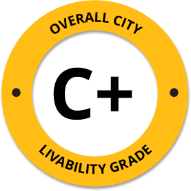
-
B+
Affordability -
F
Housing -
B
Job Market -
A-
Diversity -
A-
Crime -
B
Commute -
C-
Education -
C
Weather -
D-
Amenities
About Salem Twp, ME
Salem Twp, ME is located in Franklin County in the state of Maine.
The total City Population for Salem Twp is about 1,752 with about 12 people per square mile.
The Average Home Value is $116,500, which is roughly 41% lower than the Average Home Value of $196,619 for the state of Maine, and roughly 46% lower than the National Average of $217,072.
The Median Income Per Household is about $37,500, which is roughly 37% lower than the Average Median Income Per Household of $59,885 for the state of Maine, and roughly 42% lower higher than the National Average of $65,026.


Quick Stats
Demographic Details
Average # of People Per Household: 2.42Male Population Estimate: 51.6%
Female Population Estimate: 48.4%
Median Age: 42.9
Male Median Age: 41.6
Female Median Age: 44.5
Racial Demographic Estimates
Indian:1.31%
Asian:1.08%
Hispanic:0.97%
Black:0.4%
Hawaiian:0.06%
Other:0%
Voting


Voting Results by Party
Democratic: 45.85%
Libertarian: 2.01%
Other: 1.36%
Green: 1.04%
Crime Details
NOTE: Crime is available at the County level so this doesn't necessarily represent the city of Salem Twp specifically.
Average # of Homicides for Franklin County: About 0 per 100,000 People
(last recorded in 0)
Average # of Violent Crimes for Franklin County: About 110.993 per 100,000 People
(last recorded in 2021)
Franklin County is about 100% lower than the national average of about 4 homicides per 100,000 people, and about 61% lower than the national average of about 288 violent crimes per 100,000 people.
Employment
The Unemployment Rate for Salem Twp is about 2.2%.
Maine is ranked #11 out of 52 for Best and Worst States to Work in America, with an overall score of 68.97 out of 100.

Wage Policies
Overall Wage Policy Score: 72.42The average living wage for the state of Maine is $32.41/hr, while the states minimum wage is $12.15/hr, which can be set above the state standard, and is extended to farm workers. This gives Maine a minimum wage score of 81.24 compared to all other states.
The minimum wage for tipped employees is $6.08/hr, which gives Maine a minimum wage for tipped employees score of 35.6 compared to all other states.
The weekly unemployment (UI) benefit for Maine is $307.18, resulting in a UI benefit score of 100 compared to all other states.
Worker Protection Policies
Overall Worker Protection Score: 71.43✓ Maine does offer protections for workplace breastfeeding.
✓ Maine does mandate equal pay across gender and race.
✓ Maine does prohibit pay secrecy practices in the workplace.
✓ Maine does restrict access to salary history to reduce gender and racial bias.
X Maine does provide some form of paid family leave.
✓ Maine does provide some form of paid sick leave.
X Maine does not provide flexible scheduling of worker shifts.
X Maine does not mandate pay reporting or "call-in" pay by employers.
X Maine does not provide split shift pay regulation.
X Maine does not provide workers advanced notice of shift scheduling.
✓ Maine does provide some form of sexual harassment protection in state law.
✓ Maine does extend workers compensation mandates to farmworkers.
X Maine does not extend worker protections to domestic workers.
Right To Organize Policies
Overall Right To Organize Score: 70✓ Maine does legalize project labor agreements to ensure a fair wage to workers on contract.
X Maine does not protect workers against wage theft retaliation.
✓ Maine does partially require collective bargaining for public workers.
✓ Maine does provide collective bargaining for teachers.
✓ Maine does provide wage negotiations for teachers.
A global organization that fights inequality to end poverty and injustice.
Nearby Location
- Freeman Twp, ME ( 0.00 mi. )
- Strong, ME ( 3.11 mi. )
- Avon, ME ( 5.47 mi. )
- New Vineyard, ME ( 6.17 mi. )
- Phillips, ME ( 7.43 mi. )
- New Portland, ME ( 9.15 mi. )
- Madrid Twp, ME ( 9.18 mi. )
- N New Portlnd, ME ( 9.73 mi. )
- Temple, ME ( 9.87 mi. )
- Industry, ME ( 10.32 mi. )
- Kingfield, ME ( 10.45 mi. )
- Farmington, ME ( 11.84 mi. )
- North New Portland, ME ( 11.92 mi. )
- Carabaset Vly, ME ( 12.19 mi. )
- West Farmington, ME ( 12.46 mi. )
- W Farmington, ME ( 12.47 mi. )
- Anson, ME ( 13.83 mi. )
- Carrying Place Town Twp, ME ( 13.92 mi. )
- Caryng Pl Twp, ME ( 13.92 mi. )
- Dead River Twp, ME ( 13.92 mi. )
- Dead Rvr Twp, ME ( 13.92 mi. )
- Highland Plt, ME ( 13.92 mi. )
- Lexington Twp, ME ( 13.92 mi. )
- N New Portland, ME ( 13.92 mi. )
- Pierce Pond, ME ( 13.92 mi. )
- Pierce Pond Twp, ME ( 13.92 mi. )
- Weld, ME ( 14.03 mi. )
- Perkins Twp, ME ( 14.08 mi. )
- Starks, ME ( 15.22 mi. )
- East Wilton, ME ( 15.25 mi. )
- Wilton, ME ( 15.30 mi. )
- Embden, ME ( 15.90 mi. )
- Carrabassett Valley, ME ( 16.11 mi. )
- North Anson, ME ( 16.42 mi. )
- Farmington Falls, ME ( 16.65 mi. )
- Farmingtn Fls, ME ( 16.66 mi. )
- Dryden, ME ( 17.18 mi. )
- New Sharon, ME ( 17.24 mi. )
- Carthage, ME ( 17.57 mi. )
- East Dixfield, ME ( 18.42 mi. )
- Mercer, ME ( 19.78 mi. )
- North Jay, ME ( 19.88 mi. )
- Madison, ME ( 20.83 mi. )
- Chesterville, ME ( 20.88 mi. )
- Jay, ME ( 21.05 mi. )
- Dixfield, ME ( 21.21 mi. )
- Norridgewock, ME ( 21.80 mi. )
- Coplin Plt, ME ( 21.94 mi. )
- Dallas Plt, ME ( 21.94 mi. )
Additional Location Details
Zip Code(s): 04983Latitude: 44.835118
Longitude: -70.230954
TimeZone: Eastern (GMT -05:00)
Daylight Saving: Yes
Region: Northeast
Average Elevation: 568.0 ft.
Area Code(s): 207