Foxton's Livability
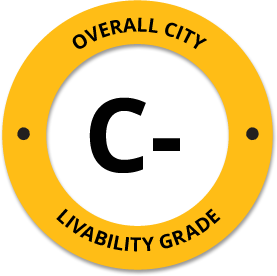
-
D+
Affordability -
F
Housing -
B-
Job Market -
C+
Diversity -
B-
Crime -
B-
Commute -
C+
Education -
C+
Weather -
F
Amenities
About Foxton, CO
Foxton, CO is located in Jefferson County in the state of Colorado.
The total City Population for Foxton is about 8,354 with about 2 people per square mile.
The Average Home Value is $434,100, which is roughly 25% higher than the Average Home Value of $325,204 for the state of Colorado, and roughly 50% higher than the National Average of $217,072.
The Median Income Per Household is about $103,173, which is roughly 32% higher than the Average Median Income Per Household of $70,131 for the state of Colorado, and roughly 37% higher higher than the National Average of $65,026.

Quick Stats
Demographic Details
Average # of People Per Household: 2.47Male Population Estimate: 51.6%
Female Population Estimate: 48.4%
Median Age: 47.2
Male Median Age: 46.8
Female Median Age: 47.5
Racial Demographic Estimates
Hispanic:3.1%
Asian:1.2%
Indian:0.9%
Other:0.8%
Black:0.6%
Hawaiian:0.1%
Voting


Voting Results by Party
Republican: 39.33%
Libertarian: 1.69%
Other: 0.81%
Green: 0.29%
Crime Details
NOTE: Crime is available at the County level so this doesn't necessarily represent the city of Foxton specifically.
Average # of Homicides for Jefferson County: About 2.38371 per 100,000 People
(last recorded in 2021)
Average # of Violent Crimes for Jefferson County: About 253.58 per 100,000 People
(last recorded in 2021)
Jefferson County is about 40% lower than the national average of about 4 homicides per 100,000 people, and about 12% lower than the national average of about 288 violent crimes per 100,000 people.
Employment
Colorado is ranked #9 out of 52 for Best and Worst States to Work in America, with an overall score of 71.88 out of 100.

Wage Policies
Overall Wage Policy Score: 73.46The average living wage for the state of Colorado is $34.94/hr, while the states minimum wage is $12.32/hr, which can be set above the state standard, and is extended to farm workers. This gives Colorado a minimum wage score of 69.67 compared to all other states.
The minimum wage for tipped employees is $9.30/hr, which gives Colorado a minimum wage for tipped employees score of 68.4 compared to all other states.
The weekly unemployment (UI) benefit for Colorado is $295.68, resulting in a UI benefit score of 80.13 compared to all other states.
Worker Protection Policies
Overall Worker Protection Score: 71.43✓ Colorado does offer protections for workplace breastfeeding.
✓ Colorado does mandate equal pay across gender and race.
✓ Colorado does prohibit pay secrecy practices in the workplace.
✓ Colorado does restrict access to salary history to reduce gender and racial bias.
✓ Colorado does provide some form of paid family leave.
✓ Colorado does provide some form of paid sick leave.
X Colorado does not provide flexible scheduling of worker shifts.
X Colorado does not mandate pay reporting or "call-in" pay by employers.
X Colorado does not provide split shift pay regulation.
X Colorado does not provide workers advanced notice of shift scheduling.
✓ Colorado does provide some form of sexual harassment protection in state law.
✓ Colorado does extend workers compensation mandates to farmworkers.
X Colorado does not extend worker protections to domestic workers.
Right To Organize Policies
Overall Right To Organize Score: 70✓ Colorado does legalize project labor agreements to ensure a fair wage to workers on contract.
X Colorado does not protect workers against wage theft retaliation.
✓ Colorado does partially require collective bargaining for public workers.
✓ Colorado does provide collective bargaining for teachers.
✓ Colorado does provide wage negotiations for teachers.
A global organization that fights inequality to end poverty and injustice.
Nearby Location
- Buffalo Creek, CO ( 3.18 mi. )
- Pine, CO ( 6.57 mi. )
- Conifer, CO ( 7.63 mi. )
- Aspen Park, CO ( 8.76 mi. )
- Roxborough, CO ( 10.78 mi. )
- Deckers, CO ( 11.73 mi. )
- Bailey, CO ( 12.72 mi. )
- Louviers, CO ( 12.99 mi. )
- Indian Hills, CO ( 14.18 mi. )
- Sedalia, CO ( 14.24 mi. )
- Morrison, CO ( 14.79 mi. )
- Evergreen, CO ( 15.47 mi. )
- Columbine Vly, CO ( 15.98 mi. )
- Columbine Valley, CO ( 16.14 mi. )
- Highlands Ranch, CO ( 16.30 mi. )
- Littleton, CO ( 16.34 mi. )
- Kittredge, CO ( 16.62 mi. )
- Idledale, CO ( 16.88 mi. )
- Shawnee, CO ( 16.97 mi. )
- Bow Mar, CO ( 17.00 mi. )
- Hghlnds Ranch, CO ( 17.12 mi. )
- Lonetree, CO ( 17.24 mi. )
- Arapahoe County Offices, CO ( 17.53 mi. )
- Littleton City Offices, CO ( 17.53 mi. )
- Fort Logan, CO ( 18.88 mi. )
- Ft Logan, CO ( 18.88 mi. )
- Sheridan, CO ( 19.25 mi. )
- Cherry Hills, CO ( 19.61 mi. )
- Cherry Hl Vlg, CO ( 19.61 mi. )
- Greenwood Vlg, CO ( 19.61 mi. )
- Castle Pines, CO ( 19.67 mi. )
- Grants Ranch, CO ( 19.86 mi. )
- Lakewood, CO ( 19.90 mi. )
- Englewood, CO ( 20.04 mi. )
- Castle Rock, CO ( 20.68 mi. )
- Lone Tree, CO ( 20.81 mi. )
- Denver Federal Center, CO ( 21.19 mi. )
- Cherry Hills Village, CO ( 21.26 mi. )
- Pleasant View, CO ( 21.66 mi. )
- Greenwood Village, CO ( 21.67 mi. )
- Golden, CO ( 21.87 mi. )
- Larkspur, CO ( 22.66 mi. )
- Grant, CO ( 22.82 mi. )
- Centennial, CO ( 22.82 mi. )
- University Of Denver, CO ( 22.88 mi. )
- Jefferson County, CO ( 22.90 mi. )
- Edgewater, CO ( 24.35 mi. )
- Tarryall, CO ( 24.50 mi. )
- Glendale, CO ( 25.06 mi. )
Additional Location Details
Zip Code(s): 80425Latitude: 39.424400
Longitude: -105.236100
TimeZone: Mountain (GMT -07:00)
Daylight Saving: Yes
Region: West
Average Elevation: 7187.0 ft.
Area Code(s): 303